Introduction
If you typed “tropical storm jerry” into a search bar, you are probably trying to figure out what this storm actually did, how strong it got, and whether it still matters today. You are in the right place. Tropical Storm Jerry formed in the Atlantic Ocean in October 2025 and quickly became a talking point across the Caribbean and the southern United States. It brought heavy rain, gusty wind, and a scare that it might grow into a hurricane.
This article walks you through everything worth knowing about Tropical Storm Jerry. You will learn where it formed, how strong it got, which islands felt its punch, and what eventually happened to it. Whether you are researching it for storm history, checking on past hurricane season activity, or just curious about how tropical systems get named and tracked, this guide covers it all in plain, simple language.
What Is Tropical Storm Jerry?
Tropical Storm Jerry was the tenth named storm of the 2025 Atlantic hurricane season. It formed from a tropical wave that moved off the coast of Africa in early October 2025. That wave drifted west across the open Atlantic, slowly gathering enough organization and warm ocean energy to earn a name.
The National Hurricane Center officially classified it as Tropical Storm Jerry on October 7, 2025. From there, it tracked west northwest toward the Leeward Islands, gaining strength along the way despite fighting against wind shear.
Where Was Tropical Storm Jerry Located?
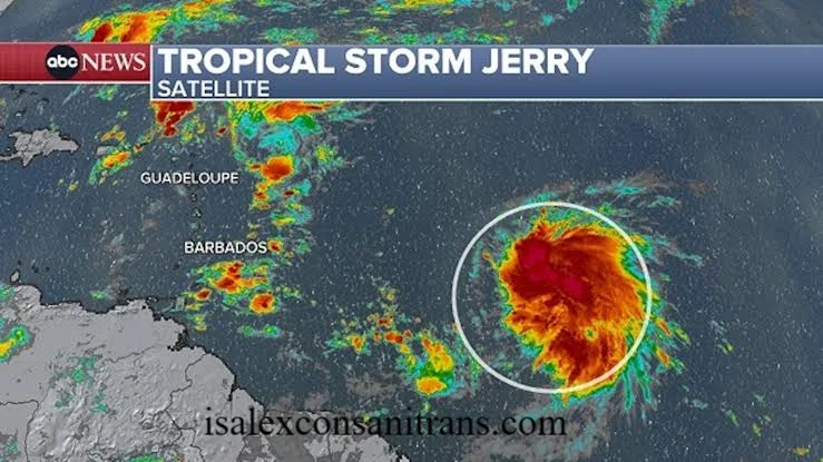
At formation, Tropical Storm Jerry sat far out in the central Atlantic, hundreds of miles east of the Leeward Islands. As days passed, it closed that distance quickly.
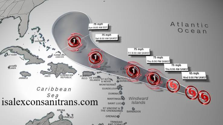
By October 9, the storm was tracking just a few hundred miles east southeast of the northern Leeward Islands. It eventually skirted the islands to the east and north rather than making a direct landfall, which spared the region from the very worst impacts.
What Was the Latest Update on Tropical Storm Jerry?
In its final days, Tropical Storm Jerry began losing steam as it turned north into cooler waters and stronger upper level wind shear. The National Hurricane Center issued its last advisory on October 11, 2025, announcing that Jerry had degenerated into a trough and was no longer a tropical cyclone.
At that point, there is no active storm using this name. If you are searching for current activity, always check the National Hurricane Center directly, since storm names get reused every six years unless retired.
Did Tropical Storm Jerry Become a Hurricane?
This was the big question during the storm’s peak days. Forecasters initially expected gradual strengthening that could push Tropical Storm Jerry into hurricane territory. However, persistent wind shear and dry air kept knocking the storm off balance.
Jerry topped out at 65 mph sustained winds, just shy of the 74 mph threshold needed for hurricane status. It never crossed that line, staying a tropical storm for its entire lifespan.
What Was the Forecast Track for Tropical Storm Jerry?
The forecast track shifted a bit day to day, which is normal for storms fighting shear. Broadly speaking, Jerry moved:
- West northwest across the open Atlantic during its early days
- Toward the northern Leeward Islands by October 9 and 10
- North and away from the Caribbean by October 11
- Into open water southeast of Bermuda before dissipating
This track kept the center of the storm just offshore of most islands, though outer bands still delivered plenty of rain and wind.
Which Areas Did Tropical Storm Jerry Impact?
Tropical Storm Jerry mainly affected the Leeward Islands. Locations that felt tropical storm force conditions included:
- Antigua and Barbuda
- Saint Kitts and Nevis
- Anguilla
- The British Virgin Islands
- The U.S. Virgin Islands
Puerto Rico and the wider Greater Antilles picked up rough surf and swells but avoided the heaviest rain bands, since Jerry stayed mostly offshore.
How Strong Were Tropical Storm Jerry’s Winds?
At peak intensity, Tropical Storm Jerry produced maximum sustained winds of 65 mph with higher gusts. Its lowest recorded central pressure was 1000 millibars.
That wind speed placed it firmly in strong tropical storm territory, capable of snapping branches, knocking out power in exposed areas, and kicking up dangerous surf, even without reaching hurricane strength.
What Rainfall and Flooding Risks Did Jerry Pose?
Rain was arguably the bigger concern with this storm. Forecasters warned of two to four inches of rain across the Leeward Islands, with isolated totals reaching six inches in spots with steep terrain.
That amount of rain falling quickly can trigger flash flooding and landslides, especially on mountainous islands where water has nowhere to go but downhill fast. Residents in the British and U.S. Virgin Islands were told to watch closely for flooding in low lying and hillside areas.
Were There Watches or Warnings for Tropical Storm Jerry?
Yes. As Tropical Storm Jerry approached the northern Leeward Islands, the National Hurricane Center issued tropical storm warnings for portions of that region. These warnings meant tropical storm conditions were expected within 36 hours, prompting local governments to activate emergency plans and urge residents to prepare.
Was Tropical Storm Jerry a Threat to the United States?
Not directly. Tropical Storm Jerry never approached the U.S. mainland or Florida. Its entire track stayed in the Atlantic and Caribbean region, curving north well before reaching the U.S. East Coast.
That said, storms like this still matter for American travelers with Caribbean plans, and swells generated far offshore can reach U.S. beaches as dangerous rip currents, even when the storm itself stays far away.
How Can You Track Storms Like Jerry Live?
For any current or future storm, the National Hurricane Center remains the gold standard source. You can also rely on:
- Local National Weather Service offices for regional alerts
- Satellite tracking sites that show real time storm position
- Official government emergency alert systems in affected countries
Checking these sources directly, rather than relying on old headlines, always gives you the most accurate and current picture.
What Safety Precautions Should Residents Take?
Even a strong tropical storm like Jerry deserves respect. If you live in a hurricane prone area, keep these basics ready year round:
- Stock several days of water, food, and medication
- Charge devices and keep backup power sources on hand
- Know your evacuation zone and local shelter locations
- Secure loose outdoor items before wind picks up
- Avoid flooded roads, even ones that look shallow
I always tell friends in coastal areas that preparation before a watch is issued beats scrambling after one. It genuinely saves stress and sometimes saves lives.
What Causes a Storm to Strengthen or Weaken?
Tropical storms like Jerry rely on warm ocean water, moist air, and light upper level wind to grow stronger. Wind shear, which is a change in wind speed or direction with height, tears storms apart by displacing their circulation from their thunderstorm activity.
Jerry struggled specifically because of persistent shear and dry air intrusion, which is exactly why it never reached hurricane strength despite favorable ocean temperatures underneath it.
How Are Tropical Storms Named?
The World Meteorological Organization maintains rotating alphabetical name lists for each ocean basin. Names get reused every six years unless a storm was so damaging or deadly that its name gets retired permanently, similar to how sports teams retire jersey numbers.
Jerry was the tenth named storm of the 2025 Atlantic season, following the alphabetical order used every year starting with A.
What Is the Difference Between a Tropical Storm and a Hurricane?
The difference comes down to wind speed. A tropical storm has sustained winds between 39 and 73 mph. Once sustained winds reach 74 mph, the system officially becomes a hurricane.
Tropical Storm Jerry peaked at 65 mph, keeping it in tropical storm classification the entire time, even though forecasters expected it to cross that threshold at one point.
Final Thoughts
Tropical Storm Jerry may not have become the hurricane some forecasts predicted, but it still delivered real impacts across the Leeward Islands through heavy rain, gusty wind, and dangerous surf. Understanding how a storm like Tropical Storm Jerry forms, tracks, and weakens helps you make sense of hurricane season news whenever the next system spins up.
If this storm history was helpful, consider sharing it with someone planning Caribbean travel or living in a hurricane prone region. And if you are tracking a different storm right now, always confirm the latest details through the National Hurricane Center before making any decisions.
isalexconsanitrans.com
Email: johanharwen314@gmail.com
Author Name: Hamid Ali
About the Author: Hamid Ali is a weather and current events writer who focuses on breaking down storm forecasts and hurricane season updates into clear, practical information for everyday readers. He enjoys helping people understand complex weather data without the technical jargon.